About Sea Temp
An interactive sea-temperature map built on the same satellite and climate data oceanographers use.
Sea Temp shows you how warm the sea really is, anywhere in the world, today and across the year. Every figure traces back to a primary scientific source (NASA/Copernicus/ECMWF), sampled as close to the coast as the data allows.
Sea temperature straight from NASA satellites
The temperature you read comes from NASA's MUR analysis, a global sea-surface-temperature field on a ~0.01° (roughly 1 km) grid and our single source for every sea temperature on Sea Temp, refreshed daily.
Historical temperatures, worldwide
For every coastal place on Earth we show historical averages of how warm the sea tends to be in each month, from ERA5, the ECMWF climate record (2021-2025).
A 10-day forecast for sea and air
Sea Temp builds its own 10-day sea-temperature forecast using the Copernicus Marine (CMEMS) ocean model. Alongside it we show the 10-day weather forecast from Apple Weather, which hundreds of millions of people already rely on, so everything you need for your next trip is in one place. It's the most reliable estimate available, but not a guarantee.
Measured at the coast, not in the open sea
We read each temperature from the satellite cell about 50 m off the beach, right where the vast majority of holidaymakers actually swim, not from open water kilometres offshore. On top of the daily satellite value we scientifically add the day's warm-up and cool-down (the diurnal cycle) hour by hour, so unlike most sites you see the sea's real-feel temperature for this very moment, not one fixed number for the whole day.
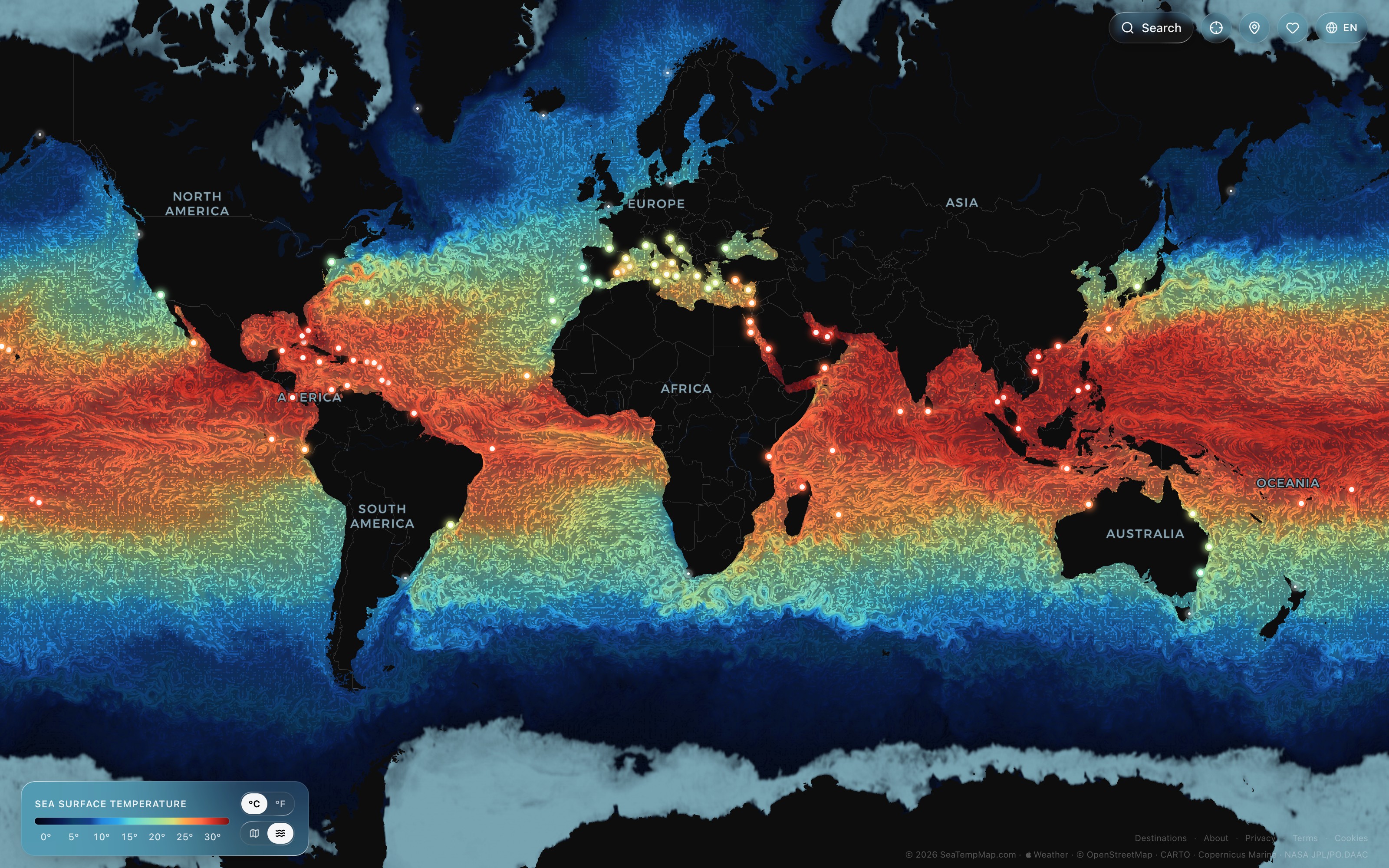
Real ocean currents and sea ice, visualized
On our interactive map you see daily-updated ocean currents drawn by more than 100,000 particles that stream across the heatmap and show their direction, speed and temperature. The currents come from the Copernicus Marine ocean model. We also refresh the sea ice daily, from NASA's MUR satellite analysis. So you get scientific-quality data, fresh every day.
Free, in 30 languages
Sea Temp is free, with no annoying ads, and offered natively in 30 of the world's languages. It also includes 174 hand-curated destinations worldwide that serve as a travel guide and give you ideas for your holiday.
See it for yourself
Open the heatmap, click the destination pins, or find any coastal town or beach using our search. The thermometer button beside it turns on a cursor you can drop anywhere on Earth to read today's sea temperature. Get inspired by photos of our hand-picked destinations; some even include a video or a live webcam.
Open the heatmap